The Remotest Places on Earth

{Image via New Scientist}

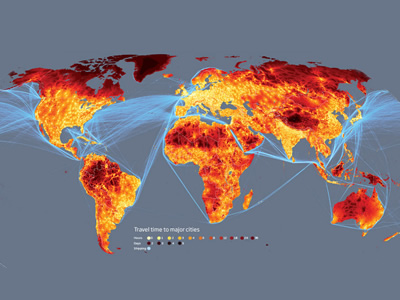
On April 18th 2009, the New Scientist published an article on a remarkable project developed by researchers at the European Commission's Joint Research Centre in Ispra, Italy, and the World Bank. The authors combined a series of maps to create a new map of connectedness showing the most interconnected and remote places on earth.

The maps are based on a model which calculated how long it would take to travel to the nearest city of 50,000 or more people by land or water. The model combines information on terrain and access to road, rail and river networks. It also considers how factors such as altitude, steepness of terrain and hold-ups like border crossings slow travel.

{Image via New Scientist}

Plotted onto a map, the results throw up surprises. First, less than 10 per cent of the world's land is more than 48 hours of ground-based travel from the nearest city. What's more, many areas considered remote and inaccessible are not as far from civilisation as you might think. In the Amazon, for example, extensive river networks and an increasing number of roads mean that only 20 per cent of the land is more than two days from a city - around the same proportion as Canada's Quebec province.

The maps were created to show how the distribution of people affects their access to resources such as education and medical care, and how we are increasingly pushing wildlife out of even the wildest corners of our planet.

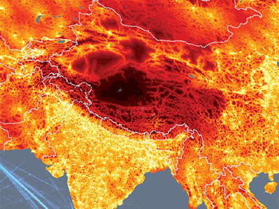
The first image shows the final map of connectedness while the second image shows a zoomed view over the world's most remote place: the Tibetan plateau. From here, says Andy Nelson, a former researcher at the European Commission, it is a three-week trip to the cities of Lhasa or Korla - one day by car and the remaining 20 on foot. Rough terrain and an altitude of 5200 metres make this the most secluded place on earth.

+Via New Scientist

A Trailer for Rage of Nature


Rage of Nature Trailer from Bianca Casimes on Vimeo. The film the Rage of Nature follows director Josh Fox on his odyssey out West, as he encounters natural gas drilling activists, advocates & victims. Then we return with him back East, as he tries to stop the oncoming tide of natural gas drilling from slamming Pennsylvania and New York. We can’t let natural gas interests hijack our transition to clean energy, while drilling continues to go unchecked.

+ Via A New F*cking Wilderness

Band-e-Amir | Afghan's First National Park

{Image via AP}War-struck Afghanis received uplifting news on Earth Day this year. Their government has announced the creation of the nation’s first national park, Band-e-Amir, protecting an epic landscape encompassing six cascading sky-blue lakes separated by natural dams. 

The park will be protecting one of Afghanistan’s most treasured natural areas. Six lakes resting high in the Hindu Kush Mountains of Central Afghanistan are separated by natural dams made from the rare mineral deposit travertine. Such systems are found in only a few place in the world, most of which are on the UNESCO World Heritage list, a future goal for Afghanistan’s first park. Pollution and human degradation of the fragile travertine dams currently threaten the park. 

"The park will draw people from Herat to Kabul to Jalalabad... to be inspired by the great beauty of Afghanistan's first national park, Band-e-Amir, " said Mostapha Zaher, Nepa's director-general.

In the stillness of the high, thin air, the blue and turquoise waters are often like glass, perfectly reflecting the slopes around them, says the BBC's Alan Johnston, who has visited Band-e-Amir.

{Image via AP}

However, this quietness may be occasionally punctured by the damaging local practice of fishing by blasting the lake waters with hand grenades, he adds.

Unfortunately much of the park’s wildlife has already been lost. But surveys for the new park found ibex; urials, a wild sheep with massive horns; wolves; foxes; and the Afghan snow finch, the only endemic bird in the country. Snow leopards used to dwell in the region but vanished during the 1980s because of hunting. 

While Band-e-Amir is not new to travelers it has been little visited since war engulfed the Afghanistan in 1979. After the nation gained some stability following the American-led invasion in 2001, thousands of Afghan tourists returned to Band-e-Amir. As well as natural beauty, the park has religious significance since it is believed the third caliph of Islam visited the region. With the new region’s status and publicity, the country hopes to attract international visitors. 

{Image via AP}

Band-e-Amir is located in Bamiyan province, which has been relatively unaffected by the violence that plagues eastern and southern Afghanistan, where Taliban fighters and other militants control swathes of land and regularly clash with international and Afghan forces.

The capital of Bamiyan is where Taliban fighters in spring 2001 blasted away two towering ancient Buddha statues carved into the region's red cliffs. Officials believe that Band-e-Amir and the remnants of the statues can combine for a powerful tourist attraction if Afghan, U.S. and NATO forces can tamp down militant violence.

USAID, the U.S. government aid arm, spent almost $1 million to help the lakes gain provisional national park status. The Wildlife Conservation Society helped identify the park's boundaries and worked with villagers living near the park.

Next on the list, Afghanistan is looking at creating a network of parks, including possible protection for the abundant wildlife in the Pamir Mountains.

As beautiful as it is, I don't see a propensity of American tourists visiting the area anytime soon.  The risk/reward simply isn't there.  But perhaps this is some kind of step to establishing something to be valued in the area.  I would think greater aide in the areas of infrastructure and school development would be of greater benefit to the Afghans, rather then U.S. backed park provisions placed on what some Afghans considered their own land, and dependent on it's resources.

{Image via AP}

Sayed Hussein runs a flour mill built three generations ago next to some waterfalls at one of the lakes.

Like many other villagers, the 60-year-old is nervous about the proposed park. To him and many others across Afghanistan, conserving natural resources is a foreign concept. Natural resources are what they depend on to survive.

Trees are cut down for firewood. Landscapes are turned into farmland and pastures used to grow food and raise livestock. Trash is hauled to the edges of one's neighborhood to be dumped or burned. Water is harnessed for consumption and power.

So to Hussein, the waterfalls next to his mill aren't something beautiful to be gawked at, they are a way to power the heavy stone wheels that grind wheat into flour.

He is reluctant to consider how he might change his life to make the park work.

But villagers do get a say in what happens here. Decisions about the proposed park and its rules are in the hands of a committee that includes not only the government in Kabul and its Western advisers, but Band-e-Amir elders and other village representatives.


Element Seeking Botanical Mobility

{Image by D.U.S.}

Plants are living creatures.  There's even been debates as to their protection and rights as living creatures, and in some cases, they've been granted those protections by governing law.  Minus that I think it makes for an interesting late night conversation, I'm not extremely interested in exploring the potential emotions of plants.

But, plants are living creatures, and will adapt and adjust their forms to accommodate to their environment. We've discussed this on D.U.S. before, diving into theories of mixing solar technology to create a fusion of botanical robotized organisms, de-shackled from ground and root structure and provided with greater mobility to seek out elemental necessities.  But mostly to promote healthier plant growth, and create urban space with dynamic qualities.

This mixing of nature and technology, whether through genetic manipulation or mechanical empowerment paints a spectrum of the wildest possibilities, from playful interaction and color, to haunting Sci-fi like imageries.

Researchers at New York University's interactive telecommunications program have come up with a device that allows plants to tell owners when they need water or if they've had too much via the social network blogging service Twitter.

The device is made of soil-moisture sensors that are connected to a circuit board. They measure the level of moisture, and then communicate the information to a microcontroller.  So it would seem that if we have the ability to control a computer from these sensors, then we could indeed incorporate these sensor controls into a mechanized, mobile system, then wa-la, plants are programmed to detect and move to water and sun sources when needed.

{"Roving Forest" image by Tomorrow's Thoughts Today}

This actually in a way occurs naturally.  For centuries in North America boreal forests have been migrating north following the retreat of glaciers and escaping a gradually warming climate.  Of course this migration occurred over thousands of years and took vast amounts of scientific research to uncover.

But what if we enabled plants with the robotized mobility discussed above.  While climates remained relatively calm their patterns of movement easily designed and controlled.  But what happens when resources become scarce and the necessity of life overpowers our control.  In the same way we can envision water, land, energy, and food wars in the future, what if trees with mechanic mobility were added to the mix.  Entire forests of water starved Elms, Oaks, and Maples march across the landscape in search of replenishment. Programmed to detect reserves, they seek and destroy satellite cities living off grid and there own water supplies.  Once designed for dynamic space in the urban setting, and to adapt to altered urban microclimates, the trees become just one other species desperately trying to survive a climate changing planet.

You can actually follow the Twittering plant mentioned above at: http://twitter.com/pothos

Apple iTunes

The iPhorest

{Image via iphorest, the app takes through the virtual steps of digging a hole, planting a seed, the comes the rain}

Available environmental activism has never before been so beautifully, or easily integrated into today's technology. iPhorest is an iphone application which enables even the most laziest of asses to aide in replenishing forests.

After downloading the $4.99 app, the iPhorest lets you go through the virtual act of planting a tree--digging a hole, planting a seedling, and creating rain storms by shaking the phone. After six shakes, the sun appears and a tree pops up. Every time a virtual tree is planted, The Conservation Fund plants a tree along the Gulf Coast. The amount of cash that goes from a single iPhorest purchase to the Conservation Fund varies depending on tree species and plant location, but some of your money goes directly to a brand new seedling. A world map also shows the locations of iPhoresters around the world.

{Image via iPhorest, the sun comes out and your tree has grown, view where all other trees have been planted}

iPhorest was introduced at last month's TED conference, where application sponsor Ecolife Apparel planted 2,200 trees for conference attendees.


Click here to download the app from the iTunes store.

[Via iPhorest]


Apple iTunes