A Walk in the Park

Toyo Ito & Associates Architects / Island City Central Park Grin Grin from 0300TV on Vimeo.

0300TV presents a video of Island City Central Park GRIN GRIN in Fukuoka designed by Toyo Ito.

Project Details:
Building Island City Central Park Grin Grin
Architects: Toyo Ito & Associates Architects
Project Team: Toyo Ito, Toyohiko Kobayashi, Hiroyuki Shinozaki, Maya Nishikori, Yoshitaka Ihara
Structural Engineers: Sasaki Structural Consultants
Program: Cultural Building
Client: Fukoka City
Constructed Area: 5000 sqm
Completed: 2005
Location: Hakata Bay, Island City, Fukuoka, Japan

Source: Architecture Lab

Planning on Visiting a California State Park this Summer? Think Again.

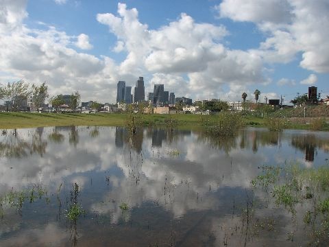
{Los Angeles Historic State Park designed by Hargreaves and Associates. Image via Fast Company}

The budgetary woes of California is old news, and months and months of an unfinished budget debate between lawmakers and Gov. Schwarzenegger are digging a deeper hole for Californians.  Just recently however the proposed budget that's now pushing for approval is one that will effectively terminate funding for California State Parks, closing 220 parks up and down the Golden State (59 will remain open).

As anyone who's visited one these parks, especially in the summertime, one can attest to their popularity as you're rarely afforded the opportunity to experience one alone.  I can only imagine the effect that the closing of so many will have on the impact of so few.  More visitors filtered to the remaining inevitably means more degradation, more trash, and less serenity.

Part of me is willing to temporarily turn the other way given the economic crisis we're in.  Unfortunately, because of the fiscal mistakes of some sacrifices will have to come from somewhere.  But, again I think lawmakers underestimate the necessity of parks, especially for overcrowded SoCal.  And can just imagine the road rage of hundreds of over-sized truck owners when urban stresses cannot be relinquished with weekend park retreats.

The California State Parks Foundation quickly declared a Save Our State Parks Weekend (also known as the more urgent SOS Weekend) which will happen statewide June 20 to June 21. During this weekend, the campaign asks citizens to visit a park and take photos of themselves, and to wear green ribbons in show of solidarity. Save Our State Parks is compiling stories about state parks and calling for mobilization through its Facebook page, when I last checked already had over 31,000 fans.

One of the most notable parks set to close is the Los Angeles Historic State Park. One of the newest parks in the state system, these 32 acres are referred to as "the Cornfield" by locals due to a large-scale artwork by Lauren Bon that planted this former railyard with corn. After drawing awareness to the area, a park was designed by the competition-winning Hargreaves Associates to create a recreation area in this greenspace-deprived neighborhood.

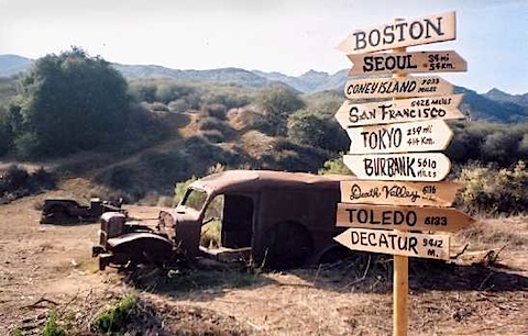
{Malibu Creek State Park. Image via Fast Company}

Another unfortunate closing would be the Malibu Creek State Park. The trails of this mountainous park northwest of Los Angeles wind through canyons, over mountains with stunning rock formations, and along the 25-mile long Malibu Creek. But the park is perhaps best known as the location for many Hollywood productions, including the TV show M*A*S*H, which left behind plenty of its vintage war vehicles.

If you'd like your voice heard you can go the California State Park Foundation website for links to petitions and their facebook page.

+ Found at Fast Company


WE are the Guardians of the Public Infrastructure

{Image via The Infrastructuralist}

We no longer have excuses for complaints that our voices cannot be heard.  Technology has given every imaginable way to organize and communicate against things we feel in the wrong.

Even in cities, above the car horns, street noise, and construction, means of pinpointing urban blight are here to give no room for them to be swept under the rug.

Through mapping technology, something I'm fond of seeing utilized in landscape contexts, is currently being developed in multiple facets in attempt to improve the lives of urban citizens.  I was recently contacted by the Environmental Mapping Technology Company SenSaris, after they read this post, to help design their personal, portable devices for measuring environmental conditions.

{Noise map around Bastille. Image via SenSaris}{SenSaris function diagram}

The mapping and measurements taken from the portable sensors directly correlate to inhabited areas to more efficiently influence which areas are in immediate of bioremediation or urban redesign.

At the social spectrum, the Infrastructionalist has created an interactive mapping system empowering citizens to pinpoint infrastructure degradation call F** This, Find It, Flag It, Fix It.  From their site:

In the land of F** This! you are granted many wonderful powers. You can become a guardian of public infrastructure. You can keep your city working smoothly. You can post pictures of busted crap–partially disassembled escalators in subway stations, cavernous potholes, permanently dark street lights–and trade snide and insightful comments with your wonderful new F** This! cyberfriends (why can’t your real life friends be this cool?). At the same time, while you’re busy enjoying yourself, we’ll see to it that the appropriate public officials get notified and the problem you identified gets dealt with. Or, if said officials prove useless in fixing the busted stuff, we’ll see to it that they endure at least some small measure of public humiliation. It’ll be fun!

{F** This map. Image via The Infrastructuralist}

While bureaucracies are a necessary evil, perhaps as tools like these become mainstays in our everyday use we become empowered to create the neighborhoods that we see fit.  If we don't, then it's a damn waste isn't it?

Fieldwork | Mobile Tree Identification

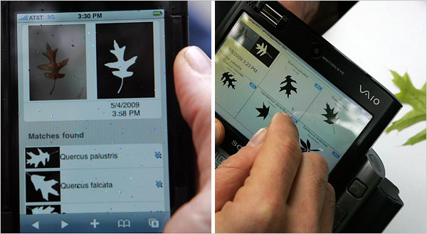
{Image via NYT. A prototype for an iPhone program, left, matches a picture of an oak leaf to a database. The prototype has been tested at Central Park in New York. Software to identify leaves by searching a field guide on a PC or a phone could be useful not only to hikers but also to scientists compiling data.}

It is important for a Landscape Architect to understand a wide variety about plants.  It is one of the many mediums used and the greater we can anticipate how a certain organism will react in a given environment, the more effective our selections will be.  

We are however not horticulturists, and the demand for us to be familiar with several disciplines limits the depth of how much we can know about each one.

Technology is coming to our aide.  And if we're criticized again by the likes of Will Alsop for not being able to identify a tree in the field, we'll simply respond, we don't have to!

A new application being developed by a team of researchers funded by the National Science Foundation gathers info from a database of thousands of images to enable you to properly identify a tree or shrub by using a photo taken from a mobile device.

As an intern or young employee, out in the field with the chore of identifying acres of existing plant life, this can be a daunting chore, especially if your plant i.d. isn't up to par.  Rather then returning to the office with hundreds of branches that you weren't quite sure of, take your iphone and handle it all in the field.

What would be the really interesting next step for this technology is to incorporate geospatial mapping to the photographed tree identity.  Once the tree is properly identified and tagged, it is recorded and color-coded onto a site plan, saving yet another step of compiling all of this field work into a accurate existing plant material plan. Perhaps even further down the road, certain infrared photo technologies will exist within smartphones that will also record and map plant health and existing ecology factors that might influence site planning matters.

+ Via The New York Times