Erratics

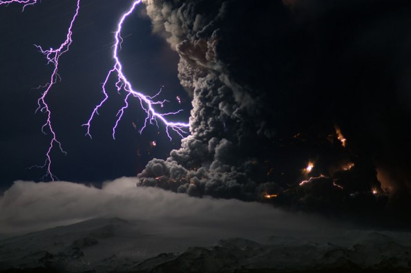
[Icelandic Eyjafjallajokull volcano. Image via Vizworld]

Storms, earthquakes, floods, and more recently volcanoes, show that geologic force, as Friends of the Pleistocene have put it, has become vividly contemporary again.

FOP presents a comparison to geologic erratics, displaced rock left behind by glaciers, and in many cases like the Doane Rock of Eastham MA, quite large, to the displacement of humans due to environmentally caused flight disruptions. The eruption of Eyjafjallajokull in Iceland grounded thousands of flights in Europe leaving human erratics stranded and strewn about their airports. Its as though the volcano had little concern with our schedules and travel arrangements, and as volcanic heat continues to combine with glacial ice, more eruptions are likely. After finding out that they to would be stranded in Spain FOP wrote:

At that point, we began to suspect that erratic was taking on a broader, more experiential definition for contemporary life for thousands of people. Might erratic aptly describe the current status of human / geologic relationality?  Given that our fragile infrastructures rely increasingly on a need for geologic forces to remain stable and oddly unchanging–perhaps erratic becoming the new norm.  Air travel, one of the most monumental achievements and inventions of humankind,  had transported us easily 3600 miles across the ocean just a few days before.  Now, suddenly, it was rendered useless.

[Erratics: A Genealogy of Rock Landscape. Image: Vignette - bedrock on beach, CCAP, January 2008 Courtesy Claude Cormier Architectes Paysagistes]

The discussion of environmentally caused human erratics or affected by, brings to mind some of the Glacier/Island/Storm writings curated by BLDGBLOG and contributions from the likes of Mammoth and Infranet Lab, among others. Human interaction/encroachment/engagement and vice versa is creating an ever evolving dynamic between man and nature. Through architecture and infrastructures, and now atmospheric geo-engineering, we have shown that we can impact earth's processes, but given a long enough time frame, the planet will always end up the victor.

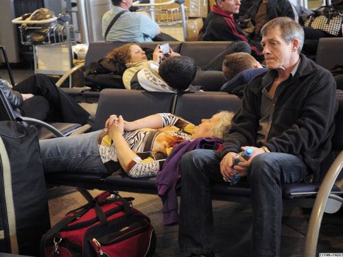
[Contemporary erratics. Image via Friends of the Pleistocene]

But as populations grow, and as extreme natural cataclysmic events continue, the prevalence of human erratics, or environmental refugees would seem to become commonplace in our cultures and thus necessitate future planning schemes for such. Imagine the displaced erratics of Hurricane Katrina reaching a continuous global scale, how would cities prepare?

FOP pointed to Michio Kaku’s words in The Wall Street Journal as a timely reminder:  Humans need to find ways to move in accord with geologic time and force, not in spite of their unpredictability, but because of them – and because of our deep entanglement with them:

“Unfortunately, our institutional memory lasts a few decades at most, while the cycles of mother Earth are usually measured in centuries or millennia. So for the future we have to appreciate that we humans will be pushed around like pawns as the earth slowly but inexorably changes and shifts.

We may think of volcanoes now as villains. But they are also givers of life. Much of the air we breathe and the ground we walk on can be traced back to ancient volcanic eruptions. And the extinction of the dinosaurs 65 million years ago (which paved the way for the coming of humans) might be traced back to a one-two punch caused by an asteroid collision and simultaneous volcanic eruptions.

The fact that humans are about 99.9% genetically identical could, according to one theory, be traced back to the Toba eruption in Indonesia roughly 70,000 years ago. That eruption might have killed off most of the human race, leaving only a few hundred of us to populate the planet. We might, therefore, owe our evolution and very existence to volcanoes.”–Michio Kaku


The Microbiological Transit Authority

In the study of Biomimicry we're discovering nature holds many potential solutions to design issues, often in a sustainable manner. Early on goose down inspired insulation, cockleburrs stuck on his dog inspired George de Mestral to invent velcro, and now perhaps, slime mold can guide our approach to large scale transit and infrastructure projects.

Researchers have used petri dish scaled mapping systems, replacing Japanese cities with slime mold food targets and recorded their routes over a 26-hr time period. The result is highly efficient path system created by tendrils that interconnect the food supplies, closely resembling to the current transit system.

The trick has to do with how slime molds eat. When Physarum polycephalum, a slime mold often found inside decaying logs, discovers bacteria or spores, it grows over them and begins to digest them through its body. To continue growing and exploring, the slime mold transforms its Byzantine pattern of thin tendrils into a simpler, more-efficient network of tubes: Those carrying a high volume of nutrients gradually expand, while those that are little used slowly contract and eventually disappear.

A nobel prize winning experiment in 2000 at Hokkaido University in Japan, showed that P. polycephalum could find the shortest path through a maze to connect two food resources. 

New research wanted to go beyond a one solution problem and involve experiment with multiple factors that would influence the path.

"The planning is very difficult because of the tradeoffs," says cell biologist Mark Fricker of the University of Oxford in the United Kingdom, who was also involved in the research. For example, connecting all cities by the shortest possible length of track often compels travelers to take highly indirect routes between any two points and can mean that a single failure isolates a large part of the network. Building in more redundancy makes the network more convenient and more resilient, but at a higher cost.

Without the obvious exclusion of geographic influence, it would be interesting to begin new transit studies with biologic diagramming. Taking political, economic, and social factors out of mega scale projects. The solutions at this stage are simply the most biologically efficient, perhaps making political rhetoric less influential on final transit design locations.

{Mold creates paths leading to oak flakes representing the surrounding cities of Tokyo}

In the opposite spectrum, could this non-partisan, non-emotional microbiological transit authority selection be used as precedent in eminent domain litigation. "The Physarum polycephalum has unfortunately chosen your homestead as the most efficient and direct path for the new railway, there is nothing that can be done."

{Conceptually proposed map of US high speed rail locations}

I would like to see this experiment done to compare similarities drawn, if any, to the current plan for the US high speed rail map. Have we selected the most righteous paths, only slime will tell (ha).

WE are the Guardians of the Public Infrastructure

{Image via The Infrastructuralist}

We no longer have excuses for complaints that our voices cannot be heard.  Technology has given every imaginable way to organize and communicate against things we feel in the wrong.

Even in cities, above the car horns, street noise, and construction, means of pinpointing urban blight are here to give no room for them to be swept under the rug.

Through mapping technology, something I'm fond of seeing utilized in landscape contexts, is currently being developed in multiple facets in attempt to improve the lives of urban citizens.  I was recently contacted by the Environmental Mapping Technology Company SenSaris, after they read this post, to help design their personal, portable devices for measuring environmental conditions.

{Noise map around Bastille. Image via SenSaris}{SenSaris function diagram}

The mapping and measurements taken from the portable sensors directly correlate to inhabited areas to more efficiently influence which areas are in immediate of bioremediation or urban redesign.

At the social spectrum, the Infrastructionalist has created an interactive mapping system empowering citizens to pinpoint infrastructure degradation call F** This, Find It, Flag It, Fix It.  From their site:

In the land of F** This! you are granted many wonderful powers. You can become a guardian of public infrastructure. You can keep your city working smoothly. You can post pictures of busted crap–partially disassembled escalators in subway stations, cavernous potholes, permanently dark street lights–and trade snide and insightful comments with your wonderful new F** This! cyberfriends (why can’t your real life friends be this cool?). At the same time, while you’re busy enjoying yourself, we’ll see to it that the appropriate public officials get notified and the problem you identified gets dealt with. Or, if said officials prove useless in fixing the busted stuff, we’ll see to it that they endure at least some small measure of public humiliation. It’ll be fun!

{F** This map. Image via The Infrastructuralist}

While bureaucracies are a necessary evil, perhaps as tools like these become mainstays in our everyday use we become empowered to create the neighborhoods that we see fit.  If we don't, then it's a damn waste isn't it?