A Central Central Park West

[Image by Douglas Jamieson / June 23, 2010]

Having spent several years in the LA area, one of my proudest achievements was eventually being somewhat able to navigate the cluster f*ck of traffic and sprawl of its satellite cities. That's not to say I don't love LA, but the city is hard to define exactly where IT rests. After 5pm little (in LA standards) takes places minus the isolated events of Staples, small venue concerts like the Wiltern, or the Disney Concert Hall. The rest of the action is scattered about the 110, 5, and 405 in the towns of the likes of Hollywood, Santa Monica, Venice, etc.

[Image via Rios Clementi Hale Studios]

A quicker then the city could handle boom after WWII sent the city in a spiraling sprawl, and with the addition of poor planning left the city with essentially no core, no public transit, and no parks.

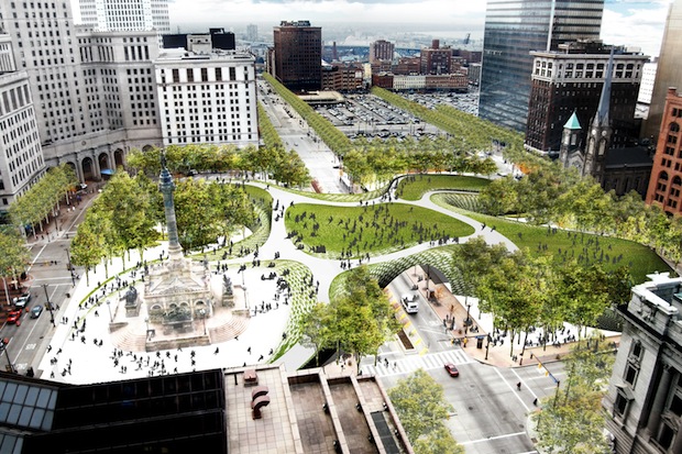
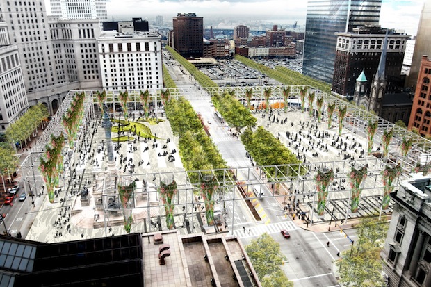
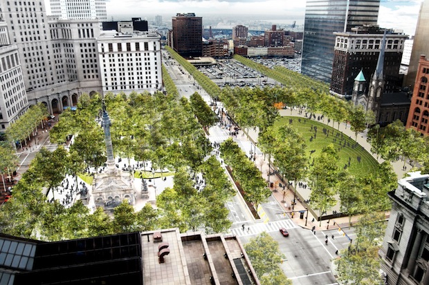
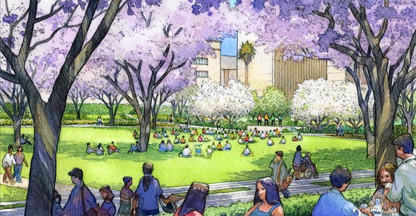
So it is encouraging to see such a focus of urban development taking place in what might the most challenging city to do it in, but I might also add with the most opportunity. We wrote last week about the Wilmington Park under construction, and this week highlight even a grander attempt at unifying the city core, the downtown Civic Park project.

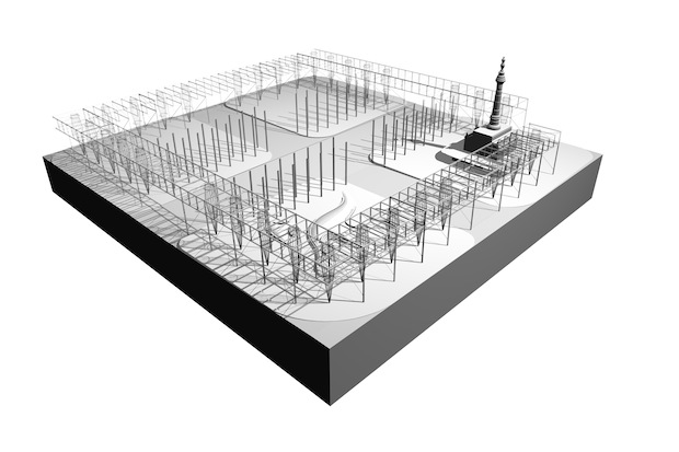
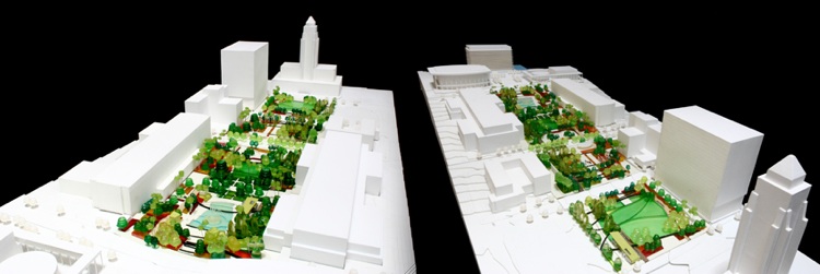
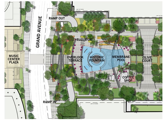
A $56-million endeavor, Rios Clementi Hale Studios were given the task to bring life into the concept, which construction crews have begun working this week on the sloping site between the Music Center and City Hall. RCHS's theme was derived from the Goode homolosine projection, a cartographer's 1923 solution for showing the curved lines of the earth's surface on a flat space.

As Rios explains them, the paths, whose curving lines recall those of a Goode map of the globe, emerged from an effort to think broadly about the remarkably diverse population the park is meant to serve. (As he likes to point out, an astonishing 92 languages are spoken by students in the Los Angeles Unified School District.) As a design gesture, the new paths turn those ideas about Los Angeles and its role as a global city into an organizing principle, at least abstractly, for the park and how visitors will move through it. Rios and other designers in the firm also studied maps and diagrams showing plane trips across the globe as well as various car and sea routes.

[Image via Rios Clementi Hale Studios]

An exciting possibility of the park is in its potential partnership with the Music Center, which would take over management of the park, bringing possibly world-renown musicians to an open downtown forum.

Naturally it wouldn't be LA without the designers having to juggle different political and economic interests along with the dizzying array of parking garages and concrete ramps, but we're excited to see local firm taking on the challenge, and look forward to its hopeful fruition.

Read more here....

The Microbiological Transit Authority

In the study of Biomimicry we're discovering nature holds many potential solutions to design issues, often in a sustainable manner. Early on goose down inspired insulation, cockleburrs stuck on his dog inspired George de Mestral to invent velcro, and now perhaps, slime mold can guide our approach to large scale transit and infrastructure projects.

Researchers have used petri dish scaled mapping systems, replacing Japanese cities with slime mold food targets and recorded their routes over a 26-hr time period. The result is highly efficient path system created by tendrils that interconnect the food supplies, closely resembling to the current transit system.

The trick has to do with how slime molds eat. When Physarum polycephalum, a slime mold often found inside decaying logs, discovers bacteria or spores, it grows over them and begins to digest them through its body. To continue growing and exploring, the slime mold transforms its Byzantine pattern of thin tendrils into a simpler, more-efficient network of tubes: Those carrying a high volume of nutrients gradually expand, while those that are little used slowly contract and eventually disappear.

A nobel prize winning experiment in 2000 at Hokkaido University in Japan, showed that P. polycephalum could find the shortest path through a maze to connect two food resources. 

New research wanted to go beyond a one solution problem and involve experiment with multiple factors that would influence the path.

"The planning is very difficult because of the tradeoffs," says cell biologist Mark Fricker of the University of Oxford in the United Kingdom, who was also involved in the research. For example, connecting all cities by the shortest possible length of track often compels travelers to take highly indirect routes between any two points and can mean that a single failure isolates a large part of the network. Building in more redundancy makes the network more convenient and more resilient, but at a higher cost.

Without the obvious exclusion of geographic influence, it would be interesting to begin new transit studies with biologic diagramming. Taking political, economic, and social factors out of mega scale projects. The solutions at this stage are simply the most biologically efficient, perhaps making political rhetoric less influential on final transit design locations.

{Mold creates paths leading to oak flakes representing the surrounding cities of Tokyo}

In the opposite spectrum, could this non-partisan, non-emotional microbiological transit authority selection be used as precedent in eminent domain litigation. "The Physarum polycephalum has unfortunately chosen your homestead as the most efficient and direct path for the new railway, there is nothing that can be done."

{Conceptually proposed map of US high speed rail locations}

I would like to see this experiment done to compare similarities drawn, if any, to the current plan for the US high speed rail map. Have we selected the most righteous paths, only slime will tell (ha).

Urban Orchard

{View of community garden and portable prefab market structure. Image via AMA}

Urban agriculture has become a well discussed topic. Competitions and student works are producing copious amounts of fascinating work and concepts: vegetated skyscrapers, deserted urban lots retrofitted to crop production and community gardens. 

Unfortunately, much of it amounts to nothing but to what a friend likes to call "render porn." Without quantifiable closed looped solutions the urban ag movement will never gain critical mass.

Andrew Maynard Architects, a young Melbourne firm in their Urban Orchard 2 concept have veered away slightly from the purely conceptual and have proposed a more actionable concept inspired by the community markets of Cuba. Cuban Market Gardens first arose as a community response to a lack of food security after the collapse of the Soviet Union. Collectively they are able to produce 90% of its citizens fruits and vegetables without the use of transport, simultaneously creating urban green areas and neighborhood integration.

{Distribution diagram. Image via AMA}{Circulation diagram. Image via AMA}{"Buildability" diagram. Image via AMA

AMA's proposal calls for the removal of transport, using rooftop garden/orchard production, sold to ground level community markets, and its food waste reused for the production biofuel.

{Circulation strategy. Image via AMA}

While on paper the idea seems like a novel idea, I still believe property owners, developers, and potential entrepreneurs will need to see actionable and profitable business plans for nobel urban ag projects to take hold, until then, enjoy the render porn.

+via Arkinet

Rethinking Cleveland's Public Square

{"The Thread" illustration. A fluidity of paths and hills.}

Cleveland, once dubbed the "mistake on the lake" is considering a major landscape architectural development. Currently divided in a peculiar four-square arrangement, three new proposals re-image Cleveland's Public Square into a united green space design.

James Corner, of Field Operations and High Line Park fame have worked directly with two nonprofit organizations, Parkworks and the Downtown Cleveland Alliance. Corner offers three radically different designs to the square. Deemed, The Frame, The Forest, and The Thread, the concepts address traffic and circulation matters to different extremes, while all providing elements of urban park goodiness.

The injection of the park into Cleveland seems a bit lofty goal, and it is. A city hit as hard as any by economic woes seems an unlikely candidate for a shoot for the stars type concept. But that was Corner's intention. Designing to a current city park budget will inevitably create mediocrity, so why not aim high, and worry about the money later.

{Three concept diagrams.}

I kind of love this approach of finding finance when pockets tighten, excite people and developers about the project, the money will maybe come with them. It seems that a general excitement is being generated around the idea, and those in power are realizing the social and eventual benefits of landscape architecture.

My favorite, and it seems the majority of interest is forming around the organic hill structure, or The Thread, a 70-foot-high manmade hill that would link all four quadrants of the square and separate pedestrians above from cars and buses below on Superior Avenue and Ontario Street. This is clearly the more iconic choice, and holds the greatest potential for spatial interest. It could be interesting to see at least a partial combination of the hill and forest concept.

{"The Frame" 3D and illustrative rendering.}

Will it ever get built in the near future? It's hard to say, but seems Cleveland officials acknowledge the impact that Corner's High Line has had, and looking for ways to make it work. As an Ohio native, I'd love to see its fruition, and hopefully keep stirring the fire in Urban Park Development. Now, if we can only do something about the Great Park?

{"The Forest" 3D concept and illustration.}Story was found here.

Local Codes | [Real] Estates

WPA2 : Local Code / Real Estates from Nicholas de Monchaux on Vimeo.

A finalist in the WPA 2.0 competition sponsored by UCLA Citylab, Nicholas de Monchaux and collaborators have provided a case study showing the impacts of the "spaces between places," spaces owned by the city but unused and still maintained. Monchaux's group, using geospatial analysis identify thousands of these publicly owned, abandoned spaces and quantify their transition into a network of urban greens.

Using San Francisco as a case study, the abandon spaces found happen to exist in areas heavenly burdened with energy efficiency and drainage issues, combining to make up an area that rivals Golden Gate Park. Local Codes/Real Estates, as the project is called, clearly displays the cost savings associated with eliminating needless infrastructural remediation while providing a healthy network of urban ecology.

Given the savings involved, this would seem quite actionable and applicable to any major city. With the intention of the individual spaces being designed by "hyperlocality," communities will be able to develop and fund their spaces to address specific needs.